


UIA LF 28/11/2018

toporient
User


2h00
Difficulty : Easy

FREE GPS app for hiking
 SityTrail
IGN / Geographical institutes
SityTrail Plus
The world is yours!
About
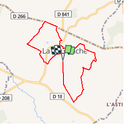
Trail Walking of 7.5 km to be discovered at Normandy, Orne, La Coulonche. This trail is proposed by toporient.
Description
Départ du parking du Stade à l'entrée sud de La Coulonche.
Nota : Le circuit court (4050m) partira du village, passera par Beau Soleil,Le Vivier, La Buatière, la Vieille Verrerie puis retour vers le village après passage en crête.
Positioning
Comments